As floods worsen in Appalachia, disaster prep gets more complex — and necessary
On the evening of Feb. 28, Kevin Babcock watched as rain fell across the Eastern Appalachian Mountains, threatening to send the Red River in Powell County, Ken., over its banks. The water came fast, and without much warning, causing record flooding in parts of eastern and central Kentucky. The state’s network of environmental monitoring stations, Kentucky Mesonet, helps local emergency managers like Babcock prepare by tracking temperature, precipitation, and historical weather data in 76 locations across the state.
However, Powell is one of several eastern counties without this technology. So, Babcock and other officials must rely on reports from other parts of the state to make predictions that inform critical decisions such as whether to issue an evacuation order.
During the floods in late February, estimates coming from the National Weather Service’s Jackson County location — more than 50 miles away — offered the best determination of how high the river might get. “We’re basically in a little valley by ourselves,” said Babcock, “I didn’t want to go to sleep if the river was rising rapidly.”
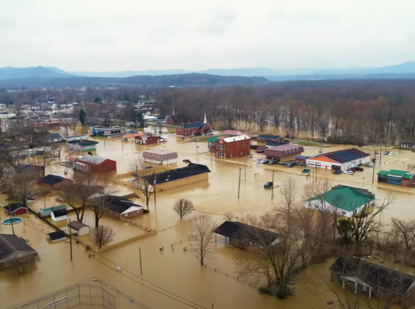
Around 3:30 a.m. on March 1, Babcock received notice that the predictions in Powell were underestimated by up to four feet: The river, normally between 8 and 12 feet deep, topped out at more than 25. More than 300 families left their homes after the flood warning was issued on Feb. 28, but “the speed and uncertainty of the flooding” led to nearly 100 water rescues, Babcock said.
Babcock said this marked the second-highest crest in modern history. Drone footage showed washed out roads; homes and businesses were partially underwater. Floodwaters inundated a fifth of the county, led to dozens of rescues, and cut off the county’s second most populous town for days.
“Since 1978 we’ve had five 40-year floods,” Babcock said of Powell County. “That’s not right, that’s not normal.”
A monitoring station closer to Powell could save lives, Babcock insisted, and he applied for a hazard mitigation grant from the Federal Emergency Management Agency (FEMA) that would fund the purchase of one for around $50,000.
“In the old days I used to rely on animals [that] moved to high ground,” Babcock said of the way he used to predict flooding. “We don’t need to do that. We have actual technology that could help us,” he said.
But other experts suggest the money could be better spent elsewhere.
Nicolas Zegre, associate professor of forest hydrology and director of West Virginia University’s Mountain Hydrology Laboratory, noted that while forecasts can be useful, they can also be wrong. He suggested that the $50,000 could go toward paying a team to work with residents to map evacuation routes, develop in-home emergency preparedness plans, and gather examples of community resilience in past disasters.
“The most important thing we can do about this is talk about this,” Zegre said. “Nothing is going to happen until there’s public discourse around this. And after we have public discourse, that’s what then influences our elected decision makers to act.”
While experts may disagree about the best response, the last few years, in particular, demonstrate the peril of flooding in Appalachia.
Kentucky’s interim climatologist, Megan Schargorodski, called what happened in the state earlier this year a “combination event” because the ground was still saturated from the winter, making drainage even more difficult. In eastern Kentucky especially, “it’s a huge problem because there’s nowhere for the water to go,” she said.
In mountainous states like the ones that make up Appalachia, heavy rain will run off hillsides, soaking the valleys beneath, and unlike the sandy soils of coastal states, clay-heavy soil found in parts of the Southern Appalachians drains water slowly. As West Virginia state climatologist Kevin Law told Southerly, five inches of rain in West Virginia might be more devastating than it would be in Florida. Flooding can be exacerbated, too, by the dangerous conditions in parts of the region damaged by coal mining: Strip mine sites can increase erosion and stream flow, leading to landslides.
The flooding in Kentucky is part of a pattern that other parts of the South are also seeing as climate change leads to more intense precipitation. That will likely continue, according to the latest Intergovernmental Panel on Climate Change assessment. In August, four people died about 45 minutes west of Asheville, N.C. after flooding caused by Tropical Storm Fred. Days later, 17 inches of water fell in a single day in middle Tennessee, causing flash flooding that killed at least 22 people. Hurricane Ida hit the Gulf Coast as a Category 4 storm, which caused minor flooding in West Virginia, but caused deadly floods a few states north.
Law, who is also a professor at Marshall University, has been studying how hurricanes making landfall are causing heavier rain inland, “possibly stalling out and dumping more rainfall in the Appalachian Mountains.” Law said it’d “definitely be advantageous” to have a more robust weather monitoring network in West Virginia, “especially in flood prone areas like the southwestern coalfields. We just don’t really have a whole lot of stations down there,” he added.
Parts of central Appalachia, including southwest Virginia, eastern Kentucky, and West Virginia, have been drenched in recent years by floods, some deadly. According to West Virginia University, more than 700 floods have occurred across the state since 2016, costing the state billions. In February 2020, heavy rains caused flooding and mudslides in southeastern Kentucky, sending trailers downstream and resulting in one death when a man was found dead in his car after he drove into flood waters. In West Virginia, flooding is “the most frequent and devastating disaster threatening” the state, according to its hazard mitigation plan, which was last updated in 2018. In June 2016, 23 people died and thousands of homes and businesses were damaged when up to 10 inches of rain fell in less than 12 hours—one of the deadliest floods in the state’s history.
People get caught off guard because they’re not prepared, said Zegre, noting that “historically, the likelihood of something big happening to any given person at any given time was less.” With more frequent, intense weather events, that is changing. And while flooding is relevant while it’s happening, he continues, the more time passes “the less important it becomes to our day-to-day.”
“That memory is only going to become relevant if we talk about it and we keep the memory fresh,” through activities like community forums and storytelling. “But that has to be intentional. And that really doesn’t happen the way it needs to,” Zegre said.
With a group of colleagues, Zegre explored this idea in a recent analysis for the journal Frontiers in Water, asserting that scientific experts should be “on equal footing” with residents in communities vulnerable to flooding. For her part, Jamie Shinn, WVU assistant professor of geography, brings a camera and recorder during interviews with survivors of the 2016 floods in Rainelle, West Virginia, to document their stories.
Among the authors most “critical” findings in the recent analysis: Drainage infrastructure, especially culverts, should be upgraded; communities should be better prepared through education; and the institutions overseeing flood preparation and response should be better run.
“They themselves are experts in their lived experience and they know what they need,” Zegre said. “Simply throwing money from the federal government down is a good start, but it’s not the end and it’s barely beginning.”
Then there’s the familiar sense that for one person “it’s hella overwhelming and complex” to consider how to affect change, Zegre said.
“At the individual level, it’s really overwhelming. It’s scary. It seems like there isn’t a solution. And I think it’s kind of the human brain to not focus on it, especially when it’s not happening all the time,” he said.
Last year First Street Foundation, a nonprofit group of hydrologists, researchers and data scientists, found that several Appalachia counties may be much more at risk of major flooding than FEMA predictions show. A 2021 analysis found that West Virginia, Kentucky, and Ohio share “a significant amount of risk” of economic damage “driven by heavy precipitation and small waterway flooding.”
FEMA has warned property owners about these risks as far back as 2010. In an advisory from that year, the agency stated: “The next time you hear hurricane — think inland flooding!” According to the National Oceanic and Atmospheric Administration, roughly a quarter of U.S. hurricane deaths between 1963 and 2012 occurred in inland counties, and half were related to freshwater flooding.
A federal disaster declaration following the Kentucky floods in late February unlocked millions in FEMA aid as hundreds of residents grappled with damage to homes and businesses — and the reality that yet another devastating flood had left its mark on the region.
This summer FEMA announced three ambitious “pre-disaster funding opportunities” including nearly $3.5 billion in hazard mitigation grants that states can use to protect against future catastrophes. That money covers three-quarters of total project costs and states or communities; Kentucky, for instance, will get $22 million for plans the state has reviewed and submitted to FEMA for funding in 2022.
“The real goal of mitigation is to reduce future damages,” said David Vandewater, a FEMA program manager for hazard mitigation assistance grants, covering Florida, Tennessee, and Kentucky.
The influx of cash supports FEMA’s existing hazard mitigation grant program, which began in the late 1980s to fund projects like retrofitting a building to improve its wind resistance, upgrading drainage systems, or purchasing a weather monitoring station like the one Babcock is seeking, among other plans. One major hazard mitigation grant project in recent years in Kentucky included the construction of a drainage basin with new culverts in Lexington. (The city had to cover just $273,000 of the $2.1 million project.)
Communities are responsible for developing a project plan that must be approved by the state and FEMA before the agency will release funding. Even applying can be a delicate process. In a 2010 video, the University of Kentucky’s hazard mitigation planning manager, who assists communities applying for grants, said project requests typically need reworking to include “FEMA language” that “maybe people out in the communities don’t know.”
By their design, hazard mitigation grants give states wide latitude to green-light projects. But the recent Frontiers in Water study of the aftermath of the 2016 flood in West Virginia suggests why that could be problematic. West Virginia’s institutions responsible for minimizing flood risks, for example, might be considered “weak” because of “policies that prioritize resource extraction-based political agenda,” the report reads. Notably, officials have taken “little-to-no action” on the plan developed by the state’s Flood Protection Task Force, according to the 2016 report.
“Strong institutions necessary to coordinate and develop community information through local floods and hazard maps, evacuation routes, and safe zones are absent. Hence, disaster preparedness stymied by weak institutional governance results in high hazards leading to greater vulnerability,” the report reads.
In Kentucky, Babcock is still waiting for final approval from FEMA for the Mesonet weather monitoring station in Powell County, which the county applied for in response to flooding in early 2019.
“It is good to know that they make sure of the needs with the limited funds available,” he said, “but it would help to be faster.”
This article was originally posted on As floods worsen in Appalachia, disaster prep gets more complex — and necessary