Researchers say increasing forest fires are ‘unhinging’ streamflow patterns in the western U.S.
Researchers have found that forested basins of the western United States saw significant increases in streamflows for about six years following large wildfires.
A new study published in the Proceedings of the National Academy of the Sciences suggests that “increasing forest fire activity is unhinging streamflow from its historically predictable response to climate variability.”
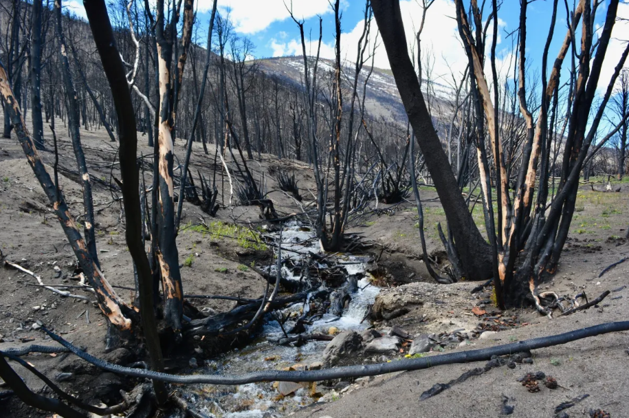
Researchers attribute enhanced streamflows following wildfire to the loss of trees, which draw moisture out of the soil; the loss of canopy cover, which intercepts precipitation before it reaches the ground; and the way wildfire can “bake” soils, making them water-repellant.
Climate modeling indicates the next three decades will bring a higher frequency of fire seasons like 2020’s, which set a modern record for forested area burned across the western U.S., they noted.
“If so, entire regions will likely experience more streamflow than expected, potentially enhancing human access to water but posing hazard management challenges,” they wrote. “Projections of water supply and runoff-related hazards must account for wildfire.”
The basins evaluated by the research team were 10 square kilometers or larger and had at least 45 years of historical streamflow data. They were also at least 25% forested and minimally disturbed by human impact, to minimize variables in the water supply equation. Researchers found that in basins where 20% or more of the forest burned, average streamflows increased about 30% over the following six years. Several western Montana basins were included in the study.
The increase in streamflow was most dramatic during spring and fall. The fall increase came as a surprise, the authors wrote, because both streamflow and transpiration — the process by which plants take up soil moisture from their roots and release it into the air as vapor — are typically lower in the fall. They say future research on post-fire fall streamflow levels could yield insights about the dominant mechanisms at work.
One of the study authors said the research points to interesting landscape-level dynamics at the intersection of drought, wildfire and water supply.
“It could be that fires seem to kind of offset drought in interesting ways in terms of water supply,” Western Water Assessment Director and University of Colorado, Boulder civil engineering professor Ben Livneh said. “The amount of water we should have had through this 20-year drought is a fair bit less than we did have, and that’s due in part to fire. … It’s almost like a correction.”
Livneh also noted that wildfire’s impact on watersheds can create water quality challenges. The erosion and sedimentation that often follow wildfire — particularly after heavy rains — can make water difficult and expensive to treat to safety standards due to ash, sediment, nutrients and contaminants.
“There’s some precedent for water [managers] essentially letting the soot-laden water flow downstream,” Livneh said. “The cost of treating that water can be prohibitive.”
From an ecological perspective, Bob Gresswell, a former U.S. Geological Survey researcher and professor emeritus in Montana State University’s Department of Ecology, said he considers three factors in discussions about how wildfire affects aquatic ecosystems: the watershed’s pre-fire biophysical characteristics, including topography, geology, vegetation cover and erosion potential; how hot the fire burned and how much vegetation it consumed; and the post-fire weather forecast, particularly in terms of precipitation.
Most landscapes tend to be pretty resilient in the face of wildfire, but a watershed prone to erosion hit with a large, hot, wind-driven fire followed by heavy rain can have detrimental effects on stream ecosystems, he said.
In some basins, a “perfect storm” scenario could send downed trees and mud slurry scouring a channel. Further downstream, larger detritus starts to settle out and finer material is deposited in streambed gravel, damaging the diversity of macroinvertebrates that fish feed on — though those impacts are generally short-lived, and fish adjust their diet to other insects as needed.
In worst-case scenarios, natural resource managers have some options to minimize fire’s impacts to aquatic ecosystems, Gresswell said. That could include collecting vulnerable species of fish with limited distributions to restock a fire-stricken stream once it has stabilized.
Gresswell added that it sometimes takes time to appreciate the benefits offered by disturbance events like wildfire. For example: Over time streams can lose large structures — logs — that provide shade and cover for fish. A wildfire can deposit new logs into the stream, which helps keep gravel and other desirable substrates in the channel.
Gresswell also emphasized that most aquatic ecosystems tend to recover just fine following wildfire. Even if a fire kills fish in smaller basins, there are often other populations living in side channels or upstream that can repopulate streams in the burn site.
Dave McWethy, an associate professor in MSU’s Department of Earth Sciences with a particular interest in disturbance ecology, said the study forefronts interesting questions about the relationship between wildfire, water supply, vegetation patterns and climate change.
McWethy has been researching expansions of woody biomass — trees and shrubs — in locations across Montana. He said a trio of factors converging in places like the Missouri River Breaks are resulting in an increase of juniper and lodgepole pine in parts of the Great Plains that have historically been dominated by grasslands.
Those factors include an overall increase in precipitation in semi-arid regions of the Northern Great Plains, an increase in the atmospheric carbon dioxide available to aid rapid plant growth, and the post-European-colonization suppression of wildfire. The absence of frequent fire has allowed species like lodgepole pine to become more established in areas where they would otherwise have been unlikely to persist, McWethy said.
That trend seems to also coincide with a reduction in streamflow, because the pines act like “straws” pulling water from soil and surface flows, McWethy said. Wildfires like 2017’s Lodgepole Complex, which burned about 270,000 acres of eastern Montana in an area that’s seen some woody plant expansion, makes the dynamic all the more interesting and complex, he said.
“The big question is which way is this going to go? Are these big fires that we’ve had in the last five years going to remove woody material and counter this woody plant expansion, or are we going to get more woody plants?”
McWethy said he’s hoping the historical record will provide clues as to what’s in store. He looks at patterns playing out in time scales on the order of thousands or tens of thousands of years.
In the nearer term, he said, he expects to see an expansion of wetlands with cattails, sedges, rushes and willows in the immediate aftermath of a wildfire, and “very dynamic” ecosystem processes, including how carbon is stored in the system and how nutrients cycle through it, which in turn affects plants and animals.
All of which complicates the work of natural resource professionals, McWethy said.
“Even though we don’t know exactly what the final trend will be, these changes are posing a lot of challenges for resource managers and fire managers,” he said.
One of those challenges centers around the seasonal availability of water. One result of temperature increases wrought by climate change is that there’s less snowpack to provide rivers with a steady supply of water, as noted in the 2017 Montana Climate Assessment. Springtime precipitation that used to fall as snow often now falls as rain, which moves through a watershed more quickly.
McWethy said “providing a more equal distribution of water, especially during the dry season” will be a challenge for water managers.
Montana is still in the grip of a stubborn drought that’s been alleviated, though not eliminated, by this winter’s snowfall. According to the U.S. Drought Monitor, 50% of the state is in extreme or exceptional drought as of March 3. That’s down from about 70% at the start of the water year, which runs Oct. 1 to Sept. 30. Northwestern Montana is generally faring better than the rest of the state in both drought and snowpack.
Streamflows around the state are very much a mixed bag. Gauges monitored by the U.S. Geological Survey indicate that many rivers in the northwestern part of the state, including the Clark Fork and Flathead, are running within normal to above-normal ranges relative to previous March 3 measurements. But a handful of rivers in the southwestern corner of the state, including the Madison, Beaverhead and Ruby, are running much below normal to below normal. Data for most central and eastern Montana rivers is not currently available. They’re listed as “ice affected,” meaning the gauges can’t take readings that represent current conditions.
This article was originally posted on Researchers say increasing forest fires are ‘unhinging’ streamflow patterns in the western U.S.